YOGYAKARTA – When we look at the jagged hills of Gunung Kidul today, it is hard to imagine that millions of years ago, this area was a deep ocean floor receiving massive avalanches of volcanic debris. A recent study on the Semilir Formation in the Ngoro-oro area (Gunung Kidul, Yogyakarta) has provided a detailed reconstruction of this ancient environment, revealing a dramatic history of submarine landslides and deep-sea fans.
The Semilir Formation: A Window to the Early Miocene
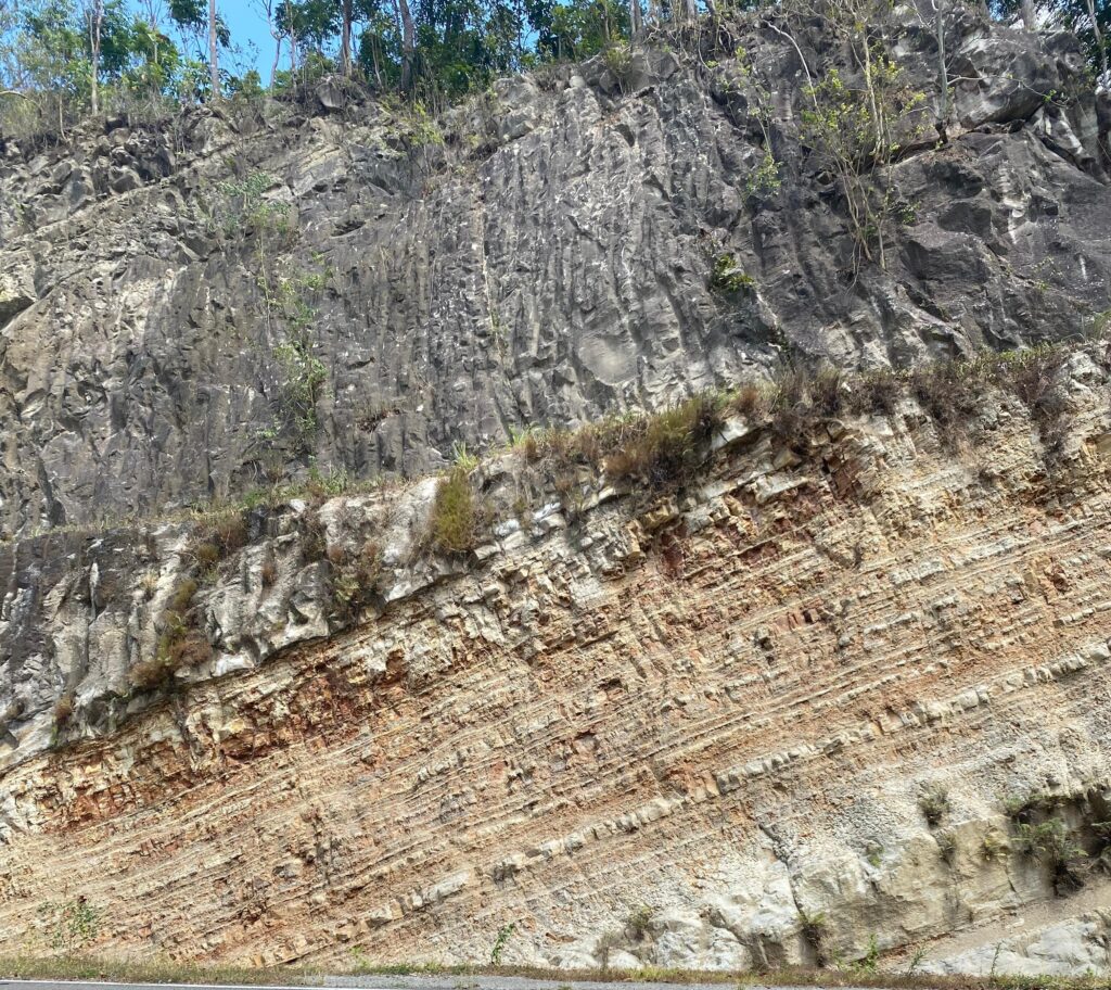
The Semilir Formation is a key geological unit in the Southern Mountains of Java, dating back to the Early Miocene. It is composed of thick volcanic rocks resulting from the intense subduction activity between the Indo-Australian and Eurasian plates
A research conducted by Yuditama et al. (2022) in Desa Ngoro-oro and Desa Gayamharjo analyzed specific outcrops to comprehend the transportation and settlement of these massive volcanic deposits. The findings present a chaotic yet captivating portrayal of the past.
Underwater Landslides and Canyons
The study identified distinct outcrops that tell a chronological story of the area:
- The Deep Sea Fan: The younger site shows more organized layering, consisting of alternating sandstone and siltstone. This change indicates a shift to turbidity currents—fast-moving, sediment-laden underwater currents that deposited material in a “Suprafan Lobe” setting (the middle to lower part of a deep-sea fan)
- The Chaotic Slope: The older sites reveal evidence of massive transport deposits (MTDs), which are essentially giant underwater landslides. Researchers discovered “debris flow” deposits and “slump” structures, which are masses of sediment that slid down the unstable slopes of an ancient volcano.
The Mystery of the Coal Fragments
One of the most intriguing findings was the discovery of coal fragments embedded within the deep-sea sandstone layers. Since coal typically forms in swamps (on land or transitional zones), how did it end up in the deep sea? The study attributes this to Hyperpycnal Flows. These are river currents so dense with sediment that when they enter the ocean, they plunge beneath the seawater, traveling along the seafloor and carrying terrestrial material—like wood and plant matter that becomes coal, far out into the deep marine basin.
Reconstructing the Ancient Landscape
Based on the lithofacies (rock characteristics) found, the researchers reconstructed the Paleogeography of Ngoro-oro:
- Phase 1: Volcanic activity triggered massive submarine landslides (MTDs), creating instability and carving out canyons on the sea slope.
- Phase 2: As the landslides eroded the slope, they formed channels.
- Phase 3: These channels became pathways for turbidity currents, which filled the canyons with organized layers of volcanic sand and silt, building up the “fan” structures we see preserved in the rocks today.
Why This Matters
Understanding the architecture of the Semilir Formation helps geologists reconstruct the tectonic evolution of Java. It confirms that the Ngoro-oro area was once a dynamic deep-marine environment dominated by the interplay of active volcanism and gravity-driven sedimentation.
For visitors to the Gunung Sewu UNESCO Global Geopark, these rocks are more than just stone; they are frozen snapshots of ancient underwater avalanches from a time when Java was just beginning to emerge from the sea.
Reference:
Yuditama, R. R., Harisulistyo, M. I., & Pramaditya, M. (2022). Arsitektur Endapan Vulkaniklastik Berdasarkan Studi Singkapan Formasi Semilir Di Daerah Ngoro-Oro, D.I.Yogyakarta. Dinamika Rekayasa, 18(1), 49-61.